Historical Development of Watford
“New development was linked with the construction of the new distributor roads through the area, with the ‘Watford By-pass’ (A41) completed by 1929 and the ‘North Orbital’ (A405) completed in 1932.”
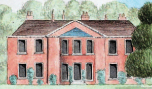
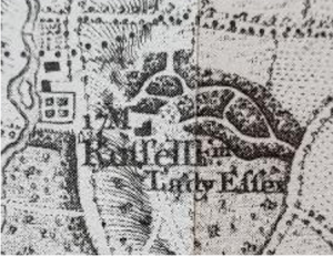
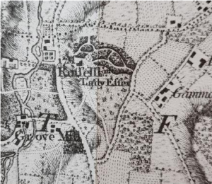
“Historical Development Before the arrival of the railway, development in Watford had been largely limited to the town’s historic core around the High Street. Development outside the centre was generally limited to farm complexes and the various buildings associated with wealthy landowners, such as Cassiobury. The agrarian nature of the area in question can be seen on the Dury and Andrews’ map from 1766, which shows the north-western part of the District largely taken up with farmland. The High Road was established by this period, although it was then known as Russell Lane, and scattered development had been built along it – with a greater concentration of buildings to the north-east. The northern part of Gammons Lane can be seen in the south-western corner of the map, while Leggatts Farm is the most significant local feature (called ‘Laggatt’s Farm’ on this map). The area that was to become Macdonnell Gardens appears to be shown as woodland at this point).”
The Estate Boundaries
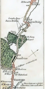
Apart from its boundary now marked by the fences at the rear of houses on the north east side of Goodwood Avenue, the Estate was enclosed by four roads of great antiquity; Hempstead Road, Russell Lane, Gammons Lane and Ridge Lane. These were all shown on Andrew Dury and John Andrews’ Topographical map of Hartfordshire, issued in May 1766 as a set of nine sheets at a scale of 1.95 inches to one mile. The map had a degree of accuracy unsurpassed until the Ordnance Survey began its work early in the nineteenth century. Indeed, copies of Dury and Andrews’ map were still being produced and sold as late as 1822.
Hempstead Road (Hemel Hempstead Road)
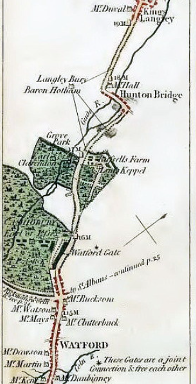
The southern section of the road through the town of Watford to Tring, Aylesbury and beyond, now the A411 before becoming the A41, is believed by some historians to have been a branch of the Roman Watling Street. There is certainly nothing to rule this out, indeed the Romans may have improved an even earlier track linking the settlements in the Gade valley. Whatever its origins, what is now the Hempstead Road, like most roads in the country, was in an atrocious state by the eighteenth century. Maintenance by unskilled parish labour, required by a sixteenth century Act of Parliament, was hopelessly inadequate in providing a road network to support the need for more efficient transport of people and goods.
This road was part of the The Sparrows Herne Turnpike Trust, which for over a century administered the highway connecting Bushey Heath and Aylesbury, via Watford, Kings Langley, Two Waters, Berkhamsted, Tring and Aston Clinton.
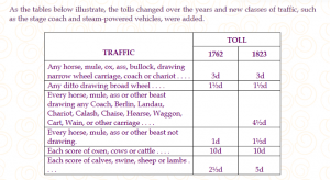
1Hertfordshire Garden History Volume Ed Deborah SpringWhile heavy goods were more efficiently carried by the canals, the improvements brought about by turnpike trusts led to a revolution in passenger transport by stage and mail coach. Residents at the mansion, and their visitors, may well have relied on these services to travel to and from the capital. The country’s road network, then as now, radiated from London. A study of the topic has found that in 1836, at the height of the coaching era, some 350 stage and Royal Mail coaches were leaving London for country places each day. Competition was fierce, especially when two or more companies operated over the same route.
Among a number of coaches passing the Estate every day on the Hempstead Road at that time were two rival coaches, The Pilot and Rodway’s Coach. A passenger taking The Pilot could choose to pay for one of the 6 inside seats or one of the 12 cheaper outside seats, on the top of the coach and exposed to the weather. Leaving London at 3-30 pm daily, and stopping at coaching inns to change horses in Edgeware, Stanmore and Watford, the coach completed its 25 mile journey to Hemel Hempstead in three and a half hours, returning to London from Hemel Hempstead at 9-00 am the following morning. Rodway’s Coach offered an identical service, stopping at the same towns and taking the same time, but departing from London and Hemel Hempstead at 8-00 am and 4-00 pm respectively. In Watford both coaches would have stopped at the Essex Arms, the coaching inn in the High Street.
Following the opening of the London and Birmingham railway to Boxmoor in 1837, there was a rapid decline in the number of long distance passengers travelling by road. As a consequence, stage coach companies went out of business and toll revenues of the Sparrows Herne Trust declined. The Trust ceased to operate in 1872 leaving the roads to predominantly local traffic. Thereafter road maintenance had to wait until County Councils took over that responsibility in 1888.
Russell Lane
This once important link between Hempstead Road and Leavesden Green was presumably so named when Tooleys became Russell Farm. It was bisected when the By Pass (A41) was built in the 1920s and its access to the A41 was later cut off, leaving the short overgrown section near its original junction with Hempstead Road. At the Leavesden end it is now Leavesden High Road.
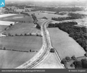
1928 Air Photograph showing the newly created North Western Avenue A41. If you look really carefully you can see the cars. The intersection with Russell Lane can be seen as well as the woodland forming a hammer head which will become Goodwood Avenue.
Gammons Lane
Gammons Farm was situated slightly to the east of the junction of the present Comyne Road and Gammons Lane. When the latter was a simple country lane, it wound its way back to the St. Albans Road at a point slightly to the north of what is now Ridge Street, and the present road follows the twists and turns of its predecessor. The name probably came from an early owner or tenant of the farm. According to one source
“Gammons Farm dates from at least 1798, when it was owned by Lady Capell. In 1798, the occupier was Mr Francis and he grew barley, wheat, seeds, oats and pease. [The land is] particularly well suited to the growing of crops, the main ones grown being wheat and barley”.
John Horncastle lived at the farm in 1841 when he was renting much of the land on the Estate surrounding the mansion from the Earl of Essex. See 19th Century Russell Farm Tenants for more on John Horncastle
Ridge Lane
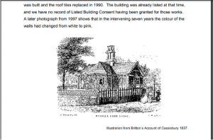
Confusingly some maps, pre-dating the Ordnance Survey, also name that part of Hempstead Road from the present town hall northwards as Ridge Lane. The present Ridge Lane follows faithfully the line of the former bridle way that ran from Hempstead Road to Gammons Lane and Gammons Farm. The Sparrows Herne Trust originally built one of its toll gates half a mile south of Ridge Lane. In 1823 this toll gate was relocated to the entrance of the Cassiobury estate, with side-gates across Ridge Lane itself and from 1854 across Russell Lane. Side-gates, or side-bars, were fitted across roads that led off the turnpike to prevent traffic from avoiding the toll by using side lanes to bypass the toll gates. The Trust also erected the milepost at what is now South Lodge, informing travellers that London was 17 miles, Watford 2 miles, Berkhampstead 9 miles, Stanmore 7 miles and Tring 14 miles. No longer there today, the milepost was still marked at the same location as late as the 1939 Ordnance Survey map.
River and Canal
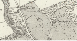
Figure 24 Hertfordshire Sheet XXXIX Surveyed: 1871 to 1872, Published: 1883
It is likely that the siting of the old kitchen garden near the river was deliberate. The canal added at the end of the 18thcentury would have ensured the supply of coal and other produce.